Report from 2021 Shelf-Wide Hypoxia Cruise
September 30, 2021

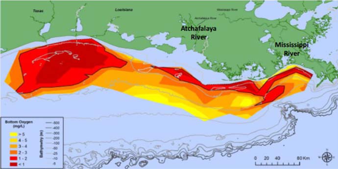
Figure 1. Distribution of bottom-water dissolved oxygen concentration for July 25-31, 2021. The combined area less than 2 mg l-1 and 1 mg l-1 are the darkest colors and outlined by the black line. Data source: NN Rabalais*+, RE Turner* & C Glaspie*, *+Louisiana State University and Louisiana Universities Marine Consortium. Funding: National Oceanic and Atmospheric Administration, National Centers for Coastal Ocean Science.
The bottom area of low oxygen in Louisiana coastal waters west of the Mississippi River, commonly known as the 'Dead Zone,' was mapped from July 25 – July 31, 2021 and estimated at 16,400 square kilometers (6,334 square miles) (Figure 1). The 2021 size is the 16th largest in 35 years of hypoxia data, i.e., average for the interval.
The forecasted size was based on the nutrient loads of Nitrate+Nitrite-N, in the month of May preceding the hypoxia research cruise (Figure 2). The May 2021 river discharge and calculated nutrient loads indicated an 'average' year, and the estimates for the size of the low oxygen area were average, indicating a size of about 12,330 square kilometers (4,760 square miles).
View the
Report from 2021 Shelf-Wide Hypoxia Cruise
